

Raise your hand if you
love National Parks!
Joshua Tree is the perfect place to explore the desert in California. A true desert wilderness just a few hours outside San Diego, Los Angeles, Las Vegas and Phoenix.
I had the pleasure of visiting in January when the weather was perfect for hiking.
Reminder if you bring something into the park,
"PACK IT OUT WITH YOU"
Hikers pick up a Joshua Tree brochure at the front entrance.
It's full of useful information about the park.

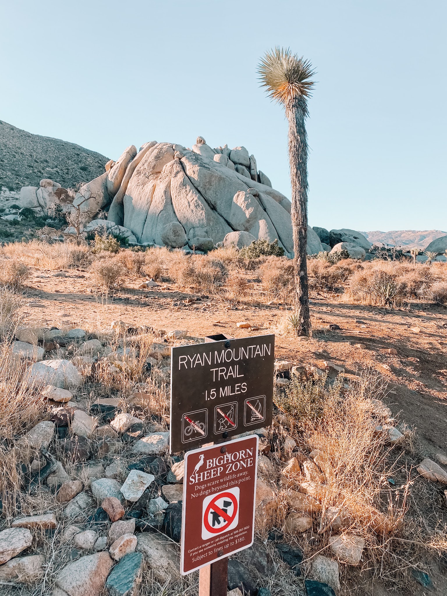
Ryan Mountain Trail
Ryan Mountain is an out and back trail. Do not be fooled like I was, with it only being a 1.5 mile trail. While this trail is mostly uphill, you are rewarded with a downhill returned trip. Ryan Mountain trail provides panoramic views of the parks landscape. Hikers, this trail provides no shade, so wear sun protection and bring plenty of WATER.


Arch Rock Trail
Arch Rock Trail will take you through a rocky and sandy terrain.
The trail is .6 miles that leads to a .2 mile loop.
The Arch is located halfway along the top.
Geological process have created this beautiful Arch over time. We must realize that in a geological framework, its existence is only for a moment, and is not the final product. Erosion or wearing away will continue. Water will dissolve minerals on the surface and will seep into tiny cracks causing them to expand and contract with extreme temperatures.
Then, one day, this Arch will tumble only to be replaced with other unique shapes and forms.


Heart Shaped Rock
As an avid hiker I always looks for "Heart" shaped rocks. This is by far the biggest I've ever seen. Pretty awesome to see a heart shaped rock in the middle of the dessert.
Located close to Arch Rock. The rock itself is 10 feet tall and sits in a boulder field.
Perfect stop for that Instagram picture.


Skull Rock
We stopped here on our way out the National Park. You can just park your car and walk up to the Skull. If you would like the take the longer path, Its an easy 1.7 mile loop hike.


Trail Information
These trails are recommended year-round and some are wheelchair accessible. If hiking in the summer, start these trails before 9 am. Information taken from National Parks Website
| Trail | Trailhead Location | Distance Elevation | Estimated Time | Description |
|---|---|---|---|---|
| Arch Rock Trail | Twin Tanks Parking lot aka the Arch Rock Trailhead | 1.4 miles (2.1 km) 100 feet | 1 hour | A lollipop trail through sandy and rocky terrain. A .6-mile trail leads to a .2-mile loop. The arch is located halfway along the loop. |
| Bajada | South of Cottonwood Visitor Center; 0.5 mile (0.8 km) north of the South Entrance | 0.25 mile (0.4 km) 20 feet (6.1 m) | 15-20 minutes | Loop. Walk on a bajada and discover plants of the Colorado Desert on this easy path. |
| Barker Dam | Barker Dam parking area | 1.1 miles (1.8 km) 50 feet (15.2 m) | 1 hour | Loop. Explore cultural history and view a water tank built by early cattle ranchers. Watch for bighorn sheep. |
| Cap Rock | Cap Rock parking area, at the junction of Park Boulevard and Keys View Road | 0.4 mile (0.6 km) 20 feet (6.1 m) | 30-45 minutes | Loop. View boulder piles, Joshua trees, and other desert plants on this easy path. |
| Cholla Cactus Garden | 20 miles (32 km) north of Cottonwood Visitor Center | 0.25 mile (0.4 km) 10 feet (3 m) | 15-30 minutes | Loop. View thousands of densely concentrated, naturally growing cholla cactus. Stay on the trail, wear closed-toe shoes, and be aware of prickly cactus. |
| Cottonwood Spring | 1 mile (1.5 km) east of Cottonwood Visitor Center | 0.1 mile (0.2 km) 25 feet (7.6 m) | 10 minutes | Short walk to fan palm oasis with cottonwood trees. Fantastic birding location with plentiful shade. |
| Discovery Trail | Skull Rock parking area just east of Jumbo Rocks Campground | 0.7 mile (1.1 km) 70 feet (21.3 m) | 30-45 minutes | Loop. Connects Skull Rock and Split Rock Loop trails at Face Rock. Easy hike through boulder piles and desert washes. |
| Hidden Valley | Hidden Valley picnic area | 1 mile (1.6 km) 100 feet (30.5 m) | 1 hour | Loop. Discover a rock-enclosed valley that was once rumored to have been used by cattle rustlers. |
| Hi-View | Northwest of Black Rock Campground | 1.3 miles (2.1 km) from parking area. 3 miles (4.8 km) from visitor center. 400 feet (121.92 m) | 1.5 hours | Loop. Discover the world of Joshua tree forests. Hike up a ridge on the western side of the park and take in panoramic views of the area. There are some steep sections, as well as a several benches to take a break and enjoy the view. |
| Indian Cove | West end of Indian Cove Campground | 0.6 miles (1 km) 50 feet (15.2 m) | 30-45 minutes | Loop. Walk on a gently rolling path with a few steps. Take a closer look at desert plants and learn about their traditional uses by Native Americans. |
| Keys View | Keys View | 0.25 miles (0.4 km) 25 feet (7.6 m) | 30 minutes | Short, paved loop path is steep. Breathtaking views of the San Andreas Fault, Mount San Jacinto, Mount San Gorgonio, and the Salton Sea. |
| Oasis of Mara | Oasis Visitor Center, Twentynine Palms | 0.5 mile (0.8 km) minimal elevation | 30-45 minutes | Loop. Explore a desert oasis on this easy walk. See how the Oasis of Mara has been used by wildlife and people throughout time. Pets on leash allowed. |
| Ryan Ranch | Ryan Ranch trailhead, about 0.5 mile (0.8 km) east of Ryan Campground | 1 mile (1.6 km) 135 feet (41.1 m) | 1 hour | Out and back. Enjoy an easy hike along an old ranch road and see a historic adobe structure. |
| Skull Rock | Skull Rock parking area just east of Jumbo Rocks Campground; also accessible from within Jumbo Rocks Campground | 1.7 miles (2.7 km) 160 feet (48.8 m) | 1-2 hours | Loop. Take an easy hike and explore boulder piles, desert washes, and of course the namesake Skull Rock. |
Moderate Hikes
These hikes may not be recommended for summer. Use caution when hiking in the desert in the heat.| Trail | Trailhead Location | Distance | Estimated Time | Description |
|---|---|---|---|---|
| Lost Horse Mine | Lost Horse Mine trailhead off Keys View Road | 4 miles (6.4 km) 550 feet (168 m) | 2-3 hours | Out and back. Explore around one of the most successful gold mines in the park. Stay outside the fenced area to protect the millsite and mine. For a longer option, see Lost Horse Loop, under Challenging Hikes. Elevation change is 550 feet. |
| Mastodon Peak | Cottonwood Spring parking area | 3 miles (4.8 km) 375 feet (115 m) | 1.5-2.5 hours | Loop. An optional rock scramble takes you to the top of a craggy granite peak. The trail then loops around past an old gold mine. Elevation change is about 375 feet. |
| Pine City | Pine City trailhead at end of Desert Queen Mine Road | 4 miles (6.4 km) | 2-3 hours | Out and back. The highlight of this fairly flat trail is a dense stand of junipers and pinyon. The trail also goes to an old mining site. |
| Split Rock Loop | Split Rock picnic area | 2.5 miles (4 km) 150 feet (45.7 m) | 1.5-2.5 hours | Loop. Distance includes safe trip to Face Rock. |
| West Side Loop | Black Rock | 4.7 miles (7.6 km) 785 feet (239.3 m) | 2.5-4 hours | Loop. Explore the ridge and washes west of Black Rock Campground |
10 Hiking Essentials


No comments